Field Border Detection and Super Resolution
Super-resolution is a technique used to increase the resolution of an image, typically using deep learning algorithms. The goal is to produce high-resolution images from low-resolution inputs that can be useful in a variety of applications such as satellite imagery, medical imaging and more.
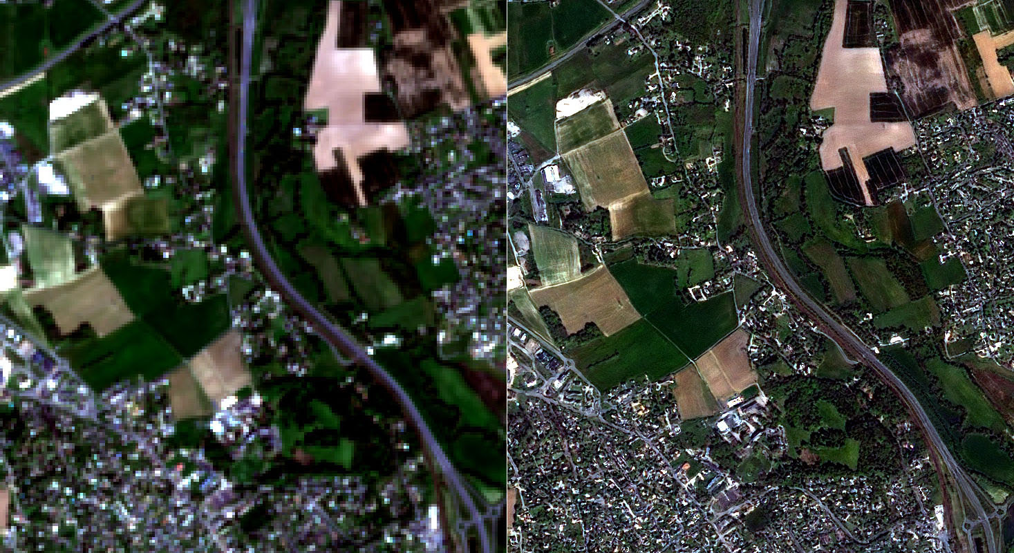
Converting Low Resolution Image to Super Resolution (Before and After Processing)
Deep learning algorithms, particularly convolutional neural networks (CNNs), have been shown to be effective at producing high-resolution images from low-resolution inputs. A popular method for super-resolution is to use a CNN to learn the mapping between low- and high-resolution images and then apply this mapping to new low-resolution images to produce high-resolution outputs.
One of the most notable applications of super-resolution is in the field of satellite imagery. Satellite images are often taken at low resolution due to the limited capabilities of the satellite camera. However, these low-resolution images can be enhanced using super-resolution techniques to produce high-resolution images that can be used for various purposes such as urban planning, disaster management and environmental monitoring.
Another application of super-resolution is in medical imaging, where high-resolution images are often needed for diagnosis and treatment planning. Super-resolution can be used to enhance low-resolution images from medical devices such as CT scanners and MRIs, which can improve the accuracy of diagnoses and the effectiveness of treatments.
In conclusion, super-resolution is a powerful technique that uses deep learning algorithms to increase the resolution of an image and can be applied in a variety of applications such as satellite imagery, medical imaging and more. Using super-resolution images can provide more accurate and detailed information and help improve decision-making in many areas.
Another application of super-resolution is in agriculture, especially the detection of field boundaries. Accurate and detailed information about field boundaries is important for a variety of tasks such as crop monitoring, yield estimation and precision farming. However, traditional methods for farm boundary detection, such as manual annotation or aerial imagery, can be time-consuming and costly.
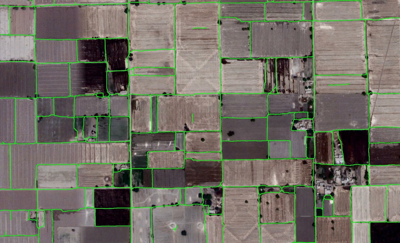
Automatic Detection of Field Borders After Super Resolution Processing
With the help of super-resolution, low-resolution satellite images rendered in high resolution can be used to detect field boundaries with high accuracy. Using deep learning algorithms to increase the resolution of low-resolution satellite images provides a more detailed view of farmland that can help identify field boundaries.
Field boundary detection algorithms using super-resolution images typically use convolutional neural networks (CNNs) to learn the mapping between low- and high-resolution images. CNNs are trained on a dataset of high-resolution images and their corresponding low-resolution images and then applied to new low-resolution images to produce high-resolution outputs.
Using super resolution in field boundary detection leads to improved accuracy and efficiency in crop monitoring, yield estimation and precision farming. By providing more detailed information about field boundaries, farmers and agribusinesses can make more informed decisions about crop management, planting patterns and resource allocation.
In summary, super-resolution is a powerful technique that can be used to improve field boundary detection in agricultural applications. The use of high-resolution satellite imagery and deep learning algorithms help identify field boundaries, enabling improved accuracy and efficiency in crop monitoring, yield estimation and precision farming.